A dedicated GPS unit is a worthwhile investment for any kayaker who ventures beyond familiar waters. Unlike a smartphone, a dedicated GPS does not rely on mobile data, has a much longer battery life, is fully waterproof, and continues to function reliably in remote areas with no cellular coverage.
For kayak fishing, touring, and sea kayaking in particular, a GPS unit that marks waypoints, tracks routes, and provides accurate positioning can make a significant difference to both safety and navigation.
We’ve reviewed 6 of the best kayak GPS units across handheld, marine, and wrist-worn options to help you find the right one.
1. Garmin GPSMap 79s – Best Overall
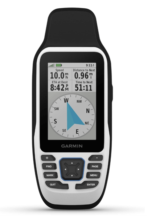
The Garmin GPSMap 79s is our top pick for the best kayak GPS. It is a marine-specific handheld designed for on-water use, with a worldwide basemap pre-loaded and optional BlueChart g2 coastal charts for Australian waters. The floating design means it will not sink if dropped overboard — an important practical consideration for kayakers.
The 2.6-inch colour display is readable in bright sunlight, and the IPX7 waterproof rating ensures reliable operation in rain, splashing, and accidental submersion. GPS and GLONASS compatibility provides accurate positioning in remote areas, and the unit runs on two AA batteries for approximately 20 hours of use.
What We Liked
- Marine-specific design with floating capability
- Pre-loaded worldwide basemap
- IPX7 waterproof rating
- GPS and GLONASS support
- 20-hour battery life on AA batteries
What We Didn’t Like
- Higher price point
- No touchscreen
2. Garmin GPSMAP 65 – Best for Navigation
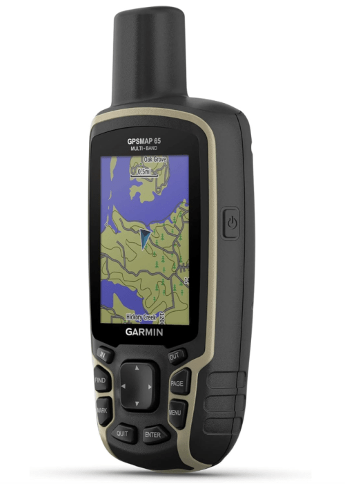
The Garmin GPSMAP 65 is a rugged handheld GPS with multi-band GNSS technology that provides significantly improved accuracy compared to single-band GPS units, particularly in challenging environments with limited sky visibility. The 2.6-inch colour display is readable in direct sunlight and the unit is IPX7 waterproof.
Pre-loaded with a worldwide basemap, the GPSMAP 65 supports additional map downloads via microSD. The quad-helix antenna provides strong satellite reception in remote areas, and the unit runs on two AA batteries for approximately 16 hours. A solid all-round navigation device for serious kayak tourers and paddlers who need reliable positioning in demanding conditions.
What We Liked
- Multi-band GNSS for superior accuracy
- Quad-helix antenna
- IPX7 waterproof
- Expandable map storage via microSD
- Rugged construction
What We Didn’t Like
- Higher price point
- No touchscreen
3. Garmin eTrex SE – Best Budget
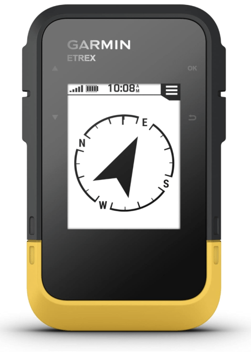
The Garmin eTrex SE is the most affordable option on this list and the best entry-level GPS for recreational kayakers. The compact handheld design is lightweight and easy to mount on a kayak deck or carry in a PFD pocket. GPS and GLONASS support provides reliable positioning, and the IPX7 waterproof rating handles splashing and rain without issue.
The 2.2-inch display is readable in most conditions, and the unit runs on two AA batteries for approximately 25 hours — the longest battery life on this list. Pre-loaded with a worldwide basemap. A practical and affordable starting point for paddlers who want reliable GPS without the cost of premium units.
What We Liked
- Most affordable option on this list
- 25-hour battery life
- IPX7 waterproof
- Lightweight and compact
- GPS and GLONASS support
What We Didn’t Like
- Basic worldwide basemap only
- Monochrome display
- Limited features compared to premium options
4. Garmin Instinct Solar – Best GPS Watch
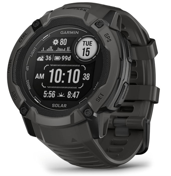
The Garmin Instinct Solar is the best GPS watch option for kayakers who want navigation and fitness tracking in a single wearable device. The solar charging capability extends battery life significantly — up to unlimited battery life in smartwatch mode with sufficient sunlight exposure, making it well suited to multi-day paddling trips.
The rugged construction meets US military standards for thermal, shock, and water resistance, and the multi-GNSS support provides accurate positioning. Features include route tracking, waypoint marking, heart rate monitoring, and a built-in compass and barometric altimeter. The small wrist-mounted display is less practical for detailed navigation than a handheld but is convenient for tracking pace, distance, and heart rate during active paddling.
What We Liked
- Solar charging for extended battery life
- Rugged military-grade construction
- Multi-GNSS support
- Heart rate monitor and fitness tracking
- Built-in compass and altimeter
What We Didn’t Like
- Small display not ideal for detailed navigation
- Higher price point
- Limited mapping compared to handheld units
5. Garmin eTrex 32x — Best Mid-Range
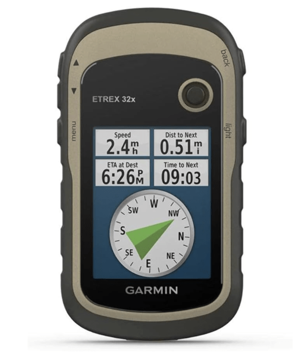
The Garmin eTrex 32x is the upgraded version of the eTrex 10 with a colour display and expanded internal memory for storing additional maps. The 2.2-inch colour screen is readable under direct sunlight, and GPS and GLONASS support with WAAS and HotFix technology provides fast and accurate satellite acquisition.
The worldwide basemap is pre-loaded and additional maps can be stored via the internal memory or microSD slot. Up to 25 hours of battery life on two AA batteries makes it practical for multi-day trips. A reliable mid-range option for paddlers who want more features than the budget eTrex SE without paying for premium marine-specific units.
What We Liked
- Colour display
- GPS, GLONASS, WAAS and HotFix support
- 25-hour battery life
- Expandable map storage
- Lightweight and durable
What We Didn’t Like
- No touchscreen
- Maps lack fine detail
6. Garmin inReach Mini 2 — Best for Remote Paddling
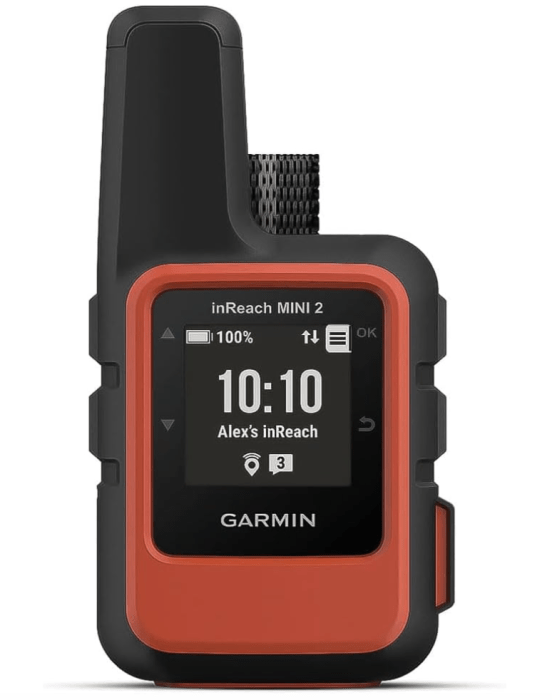
The Garmin inReach Mini 2 is not a traditional GPS navigation device — it is a satellite communicator that adds two-way messaging, SOS capability, and location sharing to any paddling trip regardless of cellular coverage. For remote sea kayaking, river touring, and expedition paddling, it provides a level of safety that no other device on this list can match.
The compact and lightweight design clips to a PFD or deck bag, and the GPS tracking allows contacts to follow your route in real time via the Garmin Explore app. Two-way messaging works anywhere in the world via the Iridium satellite network. A subscription plan is required for messaging and SOS services. For paddlers who venture into remote areas, the inReach Mini 2 is the single most important safety device available.
What We Liked
- Global two-way satellite messaging
- Interactive SOS capability
- Real-time location sharing
- Compact and lightweight
- Works anywhere in the world
What We Didn’t Like
- Requires ongoing subscription plan
- Limited navigation features compared to handheld GPS units
- Higher price point
Do You Need a Dedicated Kayak GPS?
Smartphones do have built-in GPS, but are not reliable for kayaking. Without cellular coverage, mapping apps stop working. Smartphones are also vulnerable to water damage and have relatively short battery lives compared to dedicated GPS units.
A dedicated GPS unit uses satellite-based positioning that works anywhere in the world without a mobile signal. It is waterproof, durable, and designed for outdoor use in demanding conditions. For recreational paddling close to shore, a smartphone may be sufficient. For touring, fishing, or paddling in remote areas, a dedicated GPS unit is a worthwhile investment.
What To Look For in a Kayak GPS
Type
Handheld GPS units are the most versatile option for kayaking. They are lightweight, portable, and easy to mount on a kayak deck. Marine-specific handhelds add features like tide information, nautical charts, and floating capability. GPS watches are convenient for tracking distance, speed, and heart rate but have smaller screens and less mapping detail than handhelds.
Waterproofing
Look for a minimum IPX7 waterproof rating, which means the unit can survive submersion to 1 metre for 30 minutes. Some marine GPS units float if dropped overboard, which is a useful feature for kayaking.
Battery life
Aim for at least 16 hours of battery life for day paddles. For multi-day trips, units that run on replaceable AA batteries are practical as you can carry spares. Rechargeable units with solar charging are an increasingly popular option for extended trips.
Satellite systems
Most modern GPS units support multiple satellite systems including GPS, GLONASS, and Galileo. Multi-GNSS support improves accuracy and reliability in areas with limited sky visibility such as canyons and tree-covered rivers.
Maps and charts
Pre-loaded maps vary significantly between units. Marine GPS units typically include coastal charts and nautical data. Handheld units include topographic maps. Check what maps are pre-loaded and whether additional map downloads are available for Australian waters.
Screen size and readability
A 2.6-inch screen is standard for compact handhelds. Larger screens are easier to read in bright sunlight but add weight and bulk. Look for a screen with good sunlight readability if you paddle in bright conditions.
Frequently Asked Questions (FAQs)
Do I need a GPS for kayaking?
For recreational paddling on familiar waterways close to shore, a GPS is not essential. For touring, sea kayaking, fishing in unfamiliar waters, or any paddling in remote areas, a dedicated GPS unit significantly improves both navigation and safety.
Can I use my smartphone as a kayak GPS?
A smartphone works as a basic GPS in areas with mobile coverage, but is not reliable for kayaking. Without a cellular signal, most mapping apps stop working. Smartphones are also vulnerable to water damage and have shorter battery lives than dedicated GPS units. A waterproof case can help but does not address the coverage limitation.
What is the difference between GPS and GLONASS?
GPS is the US-based satellite navigation system. GLONASS is the Russian equivalent. Units that support both systems can access more satellites simultaneously, which improves accuracy and reliability, particularly in areas with limited sky visibility such as canyons, forests, and urban environments.
What does IPX7 waterproof mean?
IPX7 means the device can withstand submersion in water up to 1 metre deep for 30 minutes. Most dedicated GPS units meet this standard as a minimum. For kayaking, IPX7 is sufficient for splashing, rain, and brief accidental submersion.
What is the Garmin inReach and do I need one?
The Garmin inReach is a satellite communicator that allows two-way messaging and SOS signalling anywhere in the world via satellite, independent of cellular coverage. For paddlers who venture into remote areas, it is a worthwhile safety investment. It requires a subscription plan for messaging services.
Final Thoughts
For most kayakers, the Garmin eTrex SE is the best starting point — affordable, reliable, waterproof, and with an excellent 25-hour battery life. For marine and coastal paddling, the Garmin GPSMap 79s is the best all-round option with its floating design and nautical chart support. For remote expedition paddling, the Garmin inReach Mini 2 provides a level of safety no other device on this list can match.
A dedicated GPS unit is the best navigation tool for most kayakers, but carrying a simple deck compass as a backup is worth considering for sea kayaking and remote paddling where battery failure could be a problem.
If you already track your fitness with a GPS watch, the Garmin Instinct Solar is a practical dual-purpose option that covers both navigation and training metrics in a single device.
For more on kayaking safety and navigation, read our guides on how to kayak at night and is kayaking dangerous.